File:Map tammar wallaby distribution.jpg
Map_tammar_wallaby_distribution.jpg (800 × 587 pixels, file size: 82 KB, MIME type: image/jpeg)
Summary
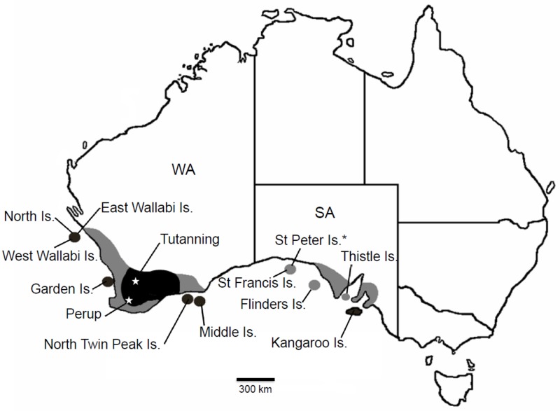
Fig 1 Former and current distribution of the tammar wallaby (Notamacropus eugenii) in Southern Australia.
Collection localities and sites mentioned in the text are indicated. Dark shading represents extant distribution; light shading represents areas where now extinct. SA = South Australia; WA = Western Australia. * = type locality. East Wallabi, West Wallabi and North Islands are part of the Houtman Abrolhos Archipelago; Middle and North Twin Peak Islands are in the Recherché Archipelago; St Francis and St Peter Islands are in the Nuyts Archipelago; Flinders Island is in the Investigator Group.
Reference
Eldridge MD, Miller EJ, Neaves LE, Zenger KR & Herbert CA. (2017). Extensive genetic differentiation detected within a model marsupial, the tammar wallaby (Notamacropus eugenii). PLoS ONE , 12, e0172777. PMID: 28257440 DOI.
Copyright
© 2017 Eldridge et al. This is an open access article distributed under the terms of the Creative Commons Attribution License, which permits unrestricted use, distribution, and reproduction in any medium, provided the original author and source are credited.
Pone.0172777.g001.jpg
File history
Click on a date/time to view the file as it appeared at that time.
| Date/Time | Thumbnail | Dimensions | User | Comment | |
|---|---|---|---|---|---|
| current | 11:56, 29 July 2019 | | 800 × 587 (82 KB) | Z8600021 (talk | contribs) | Fig 1 Former and current distribution of the tammar wallaby (Notamacropus eugenii) in Southern Australia. Collection localities and sites mentioned in the text are indicated. Dark shading represents extant distribution; light shading represents areas... |
You cannot overwrite this file.
File usage
The following page uses this file: